
About Bells Beach and Ironbark Basin
Hiking Torquay? You probably associate Torquay and Bells Beach with surfing, but there are some great hikes in this area.
LOCATION
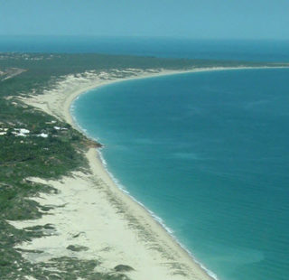
The start/finish of this hike is Bells Beach, approximately 100km west of Melbourne off the Princes Freeway and near Torquay. What a great place to go hiking! Torquay is a great place for a day trip west of Melbourne. The Ironbark Basin is part of the massive Great Otway National Park and it’s a mostly sheltered forest trail and features spectacular clifftop views of Addiscott Beach. Seriously jaw-dropping stuff.
NEAREST TOWN
Torquay and Jan Juc are the nearest towns, and Bells Beach is just a short drive from Torquay.
OPENING HOURS
You can park in the car park at the Bells Beach Surfing Reserve, anytime, day or night.
ACTIVITIES
Iron Bark basin is great for a trail run, hike or mountain bike riding. There is also a mountain biking trail out there.
GETTING THERE

Getting to Bells Beach via the Geelong bypass. Click on the map for more detail.
Take the Princes Freeway west from Melbourne and take the Geelong bypass and continue towards Torquay. Look for the turn-off to Bells Beach (Bells Beach Road) on the right just outside of Torquay. Follow this road for about 1.5kms to the Bells Beach Surfing Recreation Reserve. I suggest parking at the Southern end of the car park near the toilet block as that’s where the hike starts.
FACILITIES
There are toilets in the Bells Beach car park.
Bells Beach to Point Addis via Ironbark Basin
BE PREPARED
Bring your own water and a blindfold if you don’t want to witness wrinkly old dudes in the nuddy taking a dip at Addiscot Beach! Some things you can never unsee… 🙁
Check the tides as beach access is limited during high tide. Take the inland route if you’re unsure as it will save you having to backtrack if you can’t get through.
Iron Bark Basin Circuit Walk

Iron Bark Basin circuit. Click on the map for a larger image.
Distance: 9.3km (intended to do 11km but we went a bit off course… of course!)
Time: 2:20
Elevation gain: 253m

Iron Bark Basin elevation profile – a total gain of 253m
Follow the beach track beyond the toilet block. Go down the stairs and onto the beach, but only if you’ve checked the tide conditions as the trail becomes impassable during high tide.
At approximately 4km into the hike, leave Addiscot Beach at marker 83W, following the steps away from the beach turning right onto the Koori Culture Walk. At approximately 1.5 km later, instead of turning left where we were supposed to and going deeper into the Ironbark Basin, we got a bit off track and found ourselves walking via the closed track. Ooops! We followed a runner there, not paying great attention to the map and our surrounds and oh my, what a shame this track is closed. The views were AMAZING! But I probably shouldn’t tell you that. Eventually, we ended up at a T-intersection and turned right onto the Jarosite Track and went past the old Jarosite mine and continued to follow this pat to Jarosite Road which we walked parallel to for a few hundred metres before going back into the forest and returning to the Bells Beach Car Park.
Really nice walk, brilliant views, not a lot of people once we got away from Bells Beach, not too challenging and not too far from Melbourne 🙂
Maps
- Great Otway National Park – Torquay to Kennet River – Parks Victoria
Unfortunately, this map doesn’t show the Ironbark Basin in any great detail. - Visit Great Ocean Road – free PDF map
This map doesn’t display any detail, but it does highlight a number of walks in this area of the Otways.
Hiking books
I recommend:
- Daywalks Around Melbourne by Glenn Tempest
See Walks 50 and 51
Unfortunately, this book is no longer in print 🙁 You might be able to source on eBay. - Day Walks Melbourne by John Chapman
See Walk 2
Last modified: December 8, 2017


